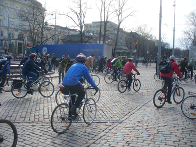
Last week I participated in two hackathons, events where a group of strangers would form a team for two or three days and build a product prototype. In the end all teams pitch their prototypes, and the best ones would be given some prizes.

Those that have been following my blog for a longer time know that I’ve been talking a lot about making the Linux desktop and mobile platforms location aware.
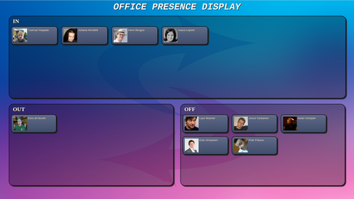
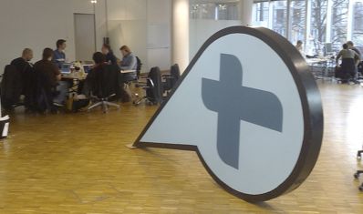
As part of the SmarcoS project, we have been investigating how to make workplaces smarter through sensors and context awareness. Here is a video showing what we’ve built:

I seem to have not blogged about this, but Open Advice, our book on Free and Open Source Software: what we wish we had known when we started, was published last month. The book was edited by Lydia Pintscher and includes essays from 42 authors, many of whom you'll recognize if you tend to go to FOSS conferences. The LWN...
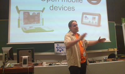
This weekend is the first-ever Finnish MeeGo Summit, held in Tampere in the same venue where we had aKademy last summer. Despite some announcements, the conference sold out in a very short time. The program looks very interesting, too. I'll give two talks: Location awareness in MeeGo, Hacks & Tricks track Friday 15:30 Midgard Create - Content Management System without...
There was a pretty interesting snippet in Engadget's coverage of yesterday's Nokia World keynote: "By 2013 800 million people will be using GPS-enabled devices. Soon, everything on the Internet will have a location coordinate. This is a space we intend to own." Indeed, this is a quite possible future, and one for which we with Midgard are quite well prepared...
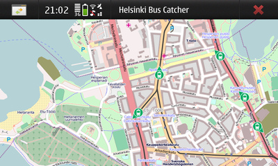
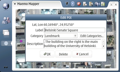
Opening public data is a hot topic in Finland at the moment. As a small experiment with the data that is available I wrote buscatcher, a simple N900 app that displays Helsinki trams (and some buses) moving on a map in real time. This makes it easy to determine when your next tram is coming to the stop, or where...
Zeitgeist, the desktop activity logging engine is now becoming geo-aware. From Seif Lotfy's blog: It allows you to ask Zeitgeist stuff like “Get me the recent files I edited at university” “Who do I contact most when I am at School?” “Which pictures did I take in Brazil?” “Where was I when an Email came in?” “What files did I...
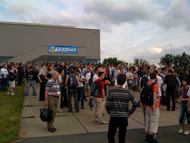
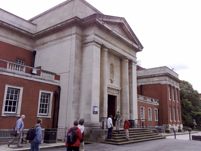
aKademy 2010 was hosted in the sunny city of Tampere by the Finnish Centre for Open Source Solutions, an organization that I'm a steering group member of. In addition to helping a bit with the arrangements and organizing the Midgard Gathering there, I also gave a talk about GeoClue, the positioning framework for Linux desktops. Presentation slides (PDF) Video of...
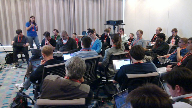
Last week was the Ubuntu Developer Summit targeted at planning how the next iteration of the operating system, Maverick Meerkat, targeted at a October 10th 2010 release, would look like. The event was held in a spa resort off in the countryside near Brussels. A place where the developers were comfortably separated from the busy towns by forests and country...
After a long hiatus there was a new GeoClue release 0.12 last week. GeoClue is a D-Bus service that Linux applications can use to obtain user's current position and convert between human-readable addresses and coordinates. As location-aware services are becoming more important and computers more mobile the free desktops should also be aware of where they are. Dadadi Blog writes:...
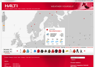
Last week the Finnish outdoor brand Halti launched a pretty interesting web service. While many outdoor brands focus on extreme sports that don't really have much to do with the reality of most of their customers, Halti connects their product lineup to the needs of the site visitor by utilizing both weather and location. This means where ever they are or...
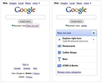
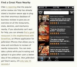
Google launched a new mobile web service called Near Me Now that can recommend things like restaurants, bars and ATMs near you. This uses browser geolocation to provide only results relevant to where you are. The idea is quite good: to replace business directories like Yelp or eat.fi with something that is easily accessible from Google's homepage and uses Google's...
Location is an important context that web services can utilize for fun or smarter user interaction. In past getting location used to be difficult, but now thanks to good IP locationing databases and browser geolocation capabilities it is becoming a lot easier. But to be really easy, the framework you're using should provide user's location built-in, without you as an...
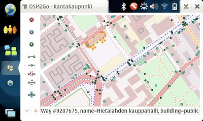
Today in the State of the Map conference I gave a lightning talk introducing Till Harbaum's OSM2Go, a wonderfully simple tool for contributing to OpenStreetMap. If you want to contribute to a freely available map of the world, download OSM2Go to your tablet and start mapping! My slides are available on SlideShare. See also my Qaiku notes for SoTM day...
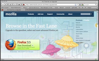
Firefox 3.5, the latest version of the best desktop browser was released yesterday. Upgrade now, and you'll get cool new features like browser geolocation and native HTML5 video support, not to mention much faster javascript. With both Firefox 3.5 and iPhone OS 3.0 out, a significant number of browsers suddenly have geolocation support. It will be interesting to see how...
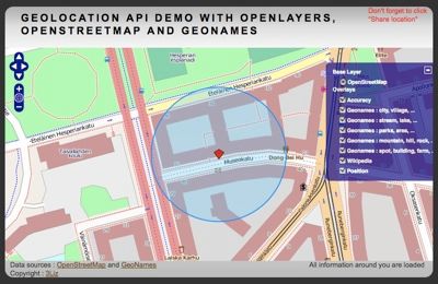
In our various GeoClue presentations we've been arguing that location comes in many flavors, of which GPS is only one. In many cases cell tower position or even WiFi connection can provide quite "good enough" location. On Mozilla Hacks they write about an OpenStreetMap-based browser location demo. I'd say the results are quite convincing: This is just a gentle reminder...
Linked Data is the W3C effort to move data out of silos and into the interconnected web. As search engines are becoming more semantically savvy, the next big thing will be establishing connections between different pieces of data by linking. Sir Berners-Lee has an excellent TED talk introducing the concept. In the talk he also shows how easy it is...
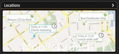
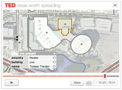
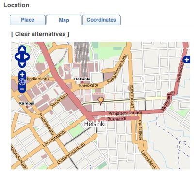
I've got no information on the validity of the claimed Harmattan screenshots that are floating around, but anyway wanted to comment on a part of it: Having your today's meetings on a map would be really cool. This is something I've wanted to do with OpenPSA ever since the days I spent motorcycling around office districts of Helsinki giving Midgard...
GUADEC will be arranged this year together with aKademy as the Gran Canaria Desktop Summit on July 3rd - 11th. The event will be an excellent opportunity to learn about some new technologies for the Linux desktop: GeoClue and libchamplain presentation (Sunday morning):GeoClue is the position information service, and libchamplain is a very nice Clutter map widget. Together they provide...

I've been beta testing the new conversation-oriented microblogging service Qaiku, and after some negotiations we today signed a cooperation agreement to join in developing the site: Qaiku is a microblogging service, focusing strongly on discussion. Microblogging differs from ordinary blogging by the length of the posts, more topical content and automatically published micromedia, such as Flickr photo stream, Audioscrobbler stream...
To make the GNOME desktop more user-friendly we should utilize context information in more places. And now that laptops are becoming more and more mobile, location is one important part of that context. For that, we developed GeoClue, the location framework that is in incubation for GNOME Mobile. Today I was talking with a student who wants to work on...
Ars Technica has a nice introductory article about GeoClue: A multitude of factors are contributing to a mobile computing renaissance. Some of these factors include the growing availability of ubiquitous mobile Internet connectivity and the rising popularity of netbooks and other Internet-enabled small form-factor devices. These changes are inspiring a renewed interest in location-aware software and web services. A framework...
FOSDEM, held in Brussels on Feb 7th and 8th, is the most important free software event of the year in Europe. While I'm going to Poland instead of there this time, the event is an excellent opportunity to learn more about two projects I'm involved with: Midgard and a replicated P2P filesystem Sun Feb 8th 2009 at 16:20, Room Ferrer...
Geohashing, as introduced by the awesome web comic xkcd, is an spontaneous adventure generator. The geohashing algorithm uses the current date and the day's Dow Jones Industrial Average to generate a new location for each region in the world. Geohashers then use various means to reach that location in search for fun and adventure. As out there was beautiful autumn...
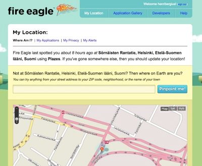
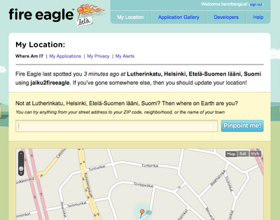
Yahoo! Fire Eagle, kind of "GeoClue for the Web" was released last week. It acts as a central hub collection position information from services like Plazes and Dopplr, and with a simple PHP script, Jaiku. Services needing user's location can then ask it from Fire Eagle instead of having to support all the services separately. Midgard's positioning framework has been...
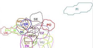
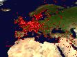
It is not only sauna, cold winters and Koskenkorva that sets us Finns apart, apparently: The map also identifies the existence of two genetic barriers within Europe. One is between the Finns (light blue, upper right) and other Europeans. It arose because the Finnish population was at one time very small and then expanded, bearing the atypical genetics of its...
I'm currently in aKademy, the KDE conference, talking about adding the geographical context into the Linux desktop. GeoClue, our solution to this problem is built to be desktop-agnostic service, and therefore the same talk has been held in both GUADEC and aKademy. Here are some notes from the conference: There was quite a good amount of interest in GeoClue. Both...
Looks like 2008 is forming up to be a quite busy conference year, at least looking at my Dopplr page. Here are the events I'm speaking (or performing as is the case with Haedong Kumdo) in this fall: Aug 2nd: Haedong Kumdo Seminar in Mayo, Ireland: part of the Finnish team Aug 9th - 10th: aKademy in Sint-Katelijne-Waver, Belgium: Location-aware...
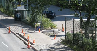
I've blogged about OpenStreetMap, the user-generated open content map service, before. Having electronic map data freely available will enable completely new solutions for navigation and experiencing our surroundings. Being user-generated, OpenStreetMap can cope with changing environment in a much better way than the proprietary offerings. For instance: When walking to office today I noticed there was construction work ongoing to...
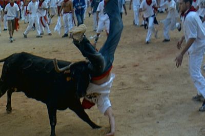
Off the Map has posted an interesting dataset of the Pamplona San Fermin bull run: In honor of the festival that kicked off this week, I thought that this was a great opportunity to show how Finder! can be a great trip planning tool. With the ability to download geographic datasets of your choice as well as create your own,...
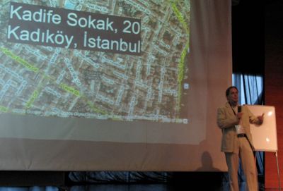
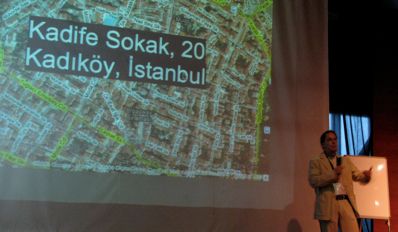
GUADEC is held in Istanbul this year, and as has been the custom in 2006 and 2007, I again came there to discuss making the Linux desktop location aware. This year I gave the "GeoClue and Gypsy - geo-information frameworks for mobile Linux desktops" talk together with Jussi Kukkonen and Iain Holmes. With Linux devices hitting more and more pockets...

On Planet GNOME I can see lots of people have already arrived to Istanbul for next week's GUADEC conference. I'm also flying there on Tuesday. On Wednesday Jussi Kukkonen, Iain Holmes and I will be talking about location-aware applications with GeoClue and Gypsy at 3:30pm in X-Large. In preparation for the talk, be sure to check out my GeoClue slides...
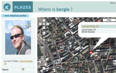
A more interesting piece of news today was that Nokia has acquired Plazes, the WiFi positioning company. I've been a Plazes user for quite a while and am using it as a position source for my website in addition to Fireeagle. I hope the acquisition will increase Plazes' resources to develop and expand the service to new areas of mobile...
GPS manufacturer Garmin has recently released the modified sources of their nüvi 880 and 5000 in-car navigators. Looking at the packages reveals that these devices are powered by GNOME Mobile and GeoClue, the toolkit for making mobile Linux applications location-aware: On downloading and Inspecting the large (and nicely organized) 8xx source tarball (list of files here) its very apparent the...
Lifehacker has an interesting story on how location-aware iPhone will change things: There's a lot of speculation as to what we can expect from next week's iPhone announcements, but there's one thing you can be sure of: The iPhone's location-aware features will change your life. Whether that means pinpointing your location on a Google Map (which iPhones already do), tracking...

I'm currently in Porto Alegre, Brazil attending the 9th International Free Software Forum (FISL) - a huge conference with some seven thousand participants. My talk in the event will be about GeoClue, the geo-information framework designed for Linux-based mobile devices. For those unable to be there or missing the 9am talk because of the parties tonight, the slides are now...
A List Apart 256 has a very interesting article on Taking Control of Your Maps, explaining how to provide richer and more customized web map solutions using tools like OpenLayers and Mapnik, and the free data provided by OpenStreetMap: For the practical developer who wants to add geospatial information to a site or application, the Google Maps API has been...
I sat down with GeoClue maintainer (and my former SoC student) Jussi Kukkonen to discuss how the project has been moving forward, and the situation is looking quite good. To those unfamiliar with GeoClue, here is a quick intro: GeoClue is a modular geoinformation service built on top of the D-Bus messaging system. The goal of the GeoClue project is...
I've been a happy user of the Jaiku S60 client for a while now. It not only allows me to coordinate things with my friends on the move, but also positions my phone using cell IDs. So far I've used the WiFi positioning based Plazes client for updating location on my site, but the thought of also using Jaiku has...
We're in the process of publishing the new corporate website today. While our web needs are actually quite simple, the site includes some nice features. As we're involved in GeoCMS development, one such feature is the active team map: The OpenStreetMap gets automatically updated as we move around. This doesn't however mean that we've GPS collared our employees, but instead...
I’ve spent today in the Plazes headquarters in Berlin attending the PlazeCamp developer event. Plazes is a social website that connects WiFi networks with geographical positioning and can be used for event coordination and as a location source for various services.
Today Finland is celebrating 90th birthday of the Republic, and so it is appropriate to write about how things are better in Sweden, where I’m visiting the first Scandinavian Free Software Conference.
Mapstraction is a javascript library that abstracts the usage of the various web map systems out there. Using it you can display Google Maps, Microsoft Virtual Earth, Yahoo! and other maps with same javascript code. And now also OpenLayers, a free software map implementation.
GeoNames is a very cool repository of open content geographical information. From the site:
I’ve written earlier how open data availability could promote public transportation. Openly available public transport schedule and route information would enable small businesses and other innovators to build new kinds of consumer route planning services. These new services in turn would help to make it easier to leave the car home and choose more sustainable transport options.
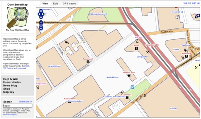
OpenStreetMap is a project for collaboratively creating open content digital maps of the world. It follows a Wikipedia-like model where interested contributors can go out with GPS receivers, and then turn those track logs into usable map content. And like Wikipedia, it is exploding in the amount of content and quality.
Midgard has had quite cool GeoCMS features for a while now: any objects can be positioned and retrieved via position, and maps are easy to display anywhere. We also can use cool services like Plazes for automatically positioning new content created by users.
Bruce Sterling is running a fictional geoblog Dispatches From the Hyperlocal Future on Wired. Much of it deals with the possibilities that the connection between GeoRSS, Microformats and neogeography with mobile devices will bring:
Last weekend and this week I’ve been off to State of the Map in Manchester and GUADEC in Birmingham to speak about the GeoClue project with Andrew Turner and Tuomas Kuosmanen.
We had some discussion about what features make CMS a GeoCMS with GeoPress and Drupal geo developers in State of the Map, and a list should be published soon. Based on our discussions I decided that Midgard should also make it easy to actually display positioned data on maps.
State of the Map, the OpenStreetMap conference was held this weekend in Manchester University, with about 100 attendees.
This summer I will be at these events:
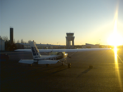
This is probably old news to many, but Google Earth is a very nice tool for visualizing flight track logs. I went yesterday to the Helsinki-Malmi airport, intending to go to the traffic circuit for some landing practice with the club’s “moped Cessna”. Instead, through the magic of the old airport, my plan was changed into flying another plane for...
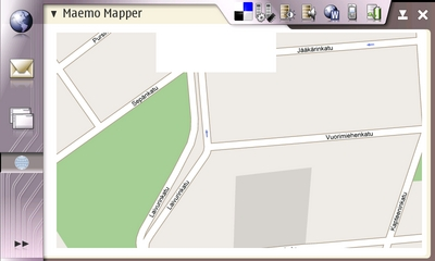
Maemo Mapper is a map browsing and GPS navigation application for the Nokia Internet Tablets. So far this useful application has been in the legal grey area by relying on providers like Google Maps and Microsoft Virtual Earth for its map tiles. This probably violates their terms of service and may cause problems later on.
Happenings this week
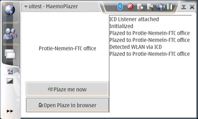
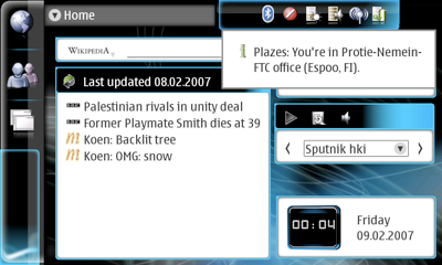
We had another Maemo hacking night here at the office. The plan was to write a proper UI for the Maemo Plazer, and integrate it with the GeoClue framework. Both of these were partially completed, but will need more thought and testing. Here’s a quick snapshot of the new UI:
Midgard is becoming smarter about tags. Now it not only supports tagging any objects and making tags contextual, but also machine tags:
Open Source Content Management System Summit 2007 will be held in Sunnyvale, CA on March 22nd and 23rd. I’ve proposed the following session:
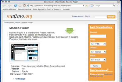
Thanks to help from Ferenc, Maemo Plazer, the Plazes client for the Nokia N800 Internet Tablet is now available:
Intergalactic hitchhikers get another treat: We have updated the older Maemo Plazer to work with the new Plazer API and the Maemo 3.0 that is on N800. We also integrated it more closely with the UI:

This is the latest iteration of my home on the web. I’ve had a website since sometime in 1994, and under this same “iki” address since 2001. This latest design was actually made in spring 2006 after our US trip, but has been waiting in mothballs for the right moment.
I was discussing this IT problem at ESEEI today: Mamona, or Castor oil plant is an oil-producing plant that can be grown in relatively dry areas. Farmers of dry areas in the state of Paraná, Brazil are generally relatively poor. Petrobras has a process where Mamona seeds can be used to produce biodiesel fuel. The IT problem related to this...

Public Geo Data is sending an open letter to the European council of environment ministers to request that the access to geographical databases would be opened to the public. While some data is open and available, we’re still far behind the US in this issue.
Plazes is a service for connecting wireless access points into physical locations. Previously this has only worked with Wi-FI networks, but now they have launched a mobile version that uses the cell phone network base station identifiers for the same thing.
New York Times has an article about using cellphones as travel guides in Japan:
I’ve committed the first working version of Midgard’s geopositioning system into CVS today. The library makes it really easy to add location information to users and objects, and to find things that are close to each other.
I’ve written before how Nokia 770 is the real Hitchhiker’s Guide to the Galaxy. The device already gives an ubiquitous access to the web, and now with the upcoming new OS release, to Jabber chat and VoIP calls.
I’ve posted thoughts about using location information on the web and my blog has been associating position information and weather on city level into all documents there since last December. However, this data isn’t very useful yet as such. As the city-level information doesn’t contain coordinates, I can’t:
Related to yesterday's geolocation post, these maps seems to be the current meme on Planet Debian:
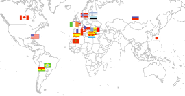
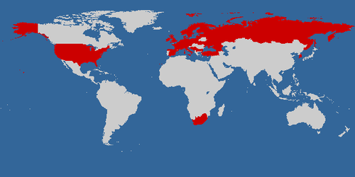
This summer's trip added another 9 to the sum. Create your own visited countries map.
The map is very similar to the ones generated by the World66, an open content travel guide.
I've today updated my blog to display the location the post was made from. The location is linked to blog postings, photos and moblog entries based on their timestamps. This is done by maintaining a database of locations with the times I've been in them in Midgard CMS. To report a new location I simply send an SMS containing the...