The Midgard Position
I’ve committed the first working version of Midgard’s geopositioning system into CVS today. The library makes it really easy to add location information to users and objects, and to find things that are close to each other.
Some things I find useful:
- Objects are positioned based on the location of the user who created them (the person who took a photo, for example)
- User’s position information is aggregated from multiple sources: manually entered data, Plazes, and eventually GPS track logs
- Any Midgard Object can be located and queried using the positioning library
The library is relatively easy to use. For example, to get and display coordinates for an article, just run the following:
 $object_position = new org_routamc_positioning_object($article);
 $coordinates = $object_position->get_coordinates();
 if (!is_null($coordinates))
 {
     echo "<meta name=\"icbm\" value=\"{$coordinates['latitude']},{$coordinates['longitude']}\" />\n";
 }
And to find 3 closest articles to this one, run:
$closest = org_routamc_positioning_utils::get_closest('midcom_db_article', $coordinates, 3);

echo "<p>Closest articles to this article are:<br />";
echo "<ol>\n";
foreach ($closest as $article)
{
    $article_coordinates = Array(
        'latitude'  => $article->latitude,
        'longitude' => $article->longitude,
    );
    echo "<li>{$article->title} is " . round(org_routamc_positioning_utils::get_distance($coordinates, $article_coordinates)) . " kilometers " . org_routamc_positioning_utils::get_bearing($coordinates, $article_coordinates) . " from you</li>";
}
echo "</ol>\n";
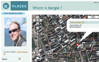
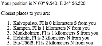
The positioning library isn’t yet hooked into any of the components yet, but I will do this soon, starting from the blog component. However, the library can already be experimented with using the test tools it contains. For example, I can see the following information based on my Plazes position:
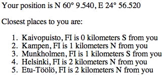
The city database used for the example above is MaxMind’s Open Sourced World Cities Database that the positioning library is able to import. Next I will start playing with the Geo-Names Data.
As soon as the library is hooked to the blog component it will replace the old location system I’ve been using on my site, and will start populating the Death Monkey 2006 route map with real-time data from that trip.
Continue reading
Position editing widget for Midgard